In June, 1997, a beautiful pocket of blue-green microcline (v. amazonite) specimens was discovered in the classic Lake George, Colorado amazonite mining area. The specimens were discovered 2 meters beneath the surface, inside a collapsed pocket, eventually named the Tree Root Pocket. About 100 fine pieces were removed in addition to several hundred lesser pieces. Many of the pieces consist of groups containing amazonite, quartz and (sometimes) white albite. The discovery came after three summers of exploration, test trenching, and open pit mining. Colorado is well known for its unique combination of amazonite and smoky quartz crystals. The blue-green microcline feldspar and rich black smoky quartz crystals create an unparalleled contrast making these specimens highly prized among collectors. Though many weekend prospectors have combed hillsides digging with hand tools, few have had the resources to mine these valuable specimens with mechanized equipment. Collectors Edge Minerals, Inc. had the opportunity in 1996-1997 to mine in Teller County, under a lease agreement, using mechanized equipment. The following project review provides historical and geologic information concerning the amazonite/ smoky quartz occurrence at the Two Point Mine and the efforts of Collector’s Edge Minerals, Inc. (CEMI) to conduct specimen mining and recovery during the 1996-1997 season. Though effort continued beyond 1997, only the first two years are summarized here.
Location
The Two Point Mine is located on a small mining claim in Teller County, Colorado, approximately 65 km west of Colorado Springs, Colorado near Lake George. Access to the claim and Mine is via a 4-wheel drive road trail that is accessed from Lake George, Colorado by driving north on public roads through private property onto National Forest land. The area is mountainous with rugged terrain of forest and rock. Much of the potential prospect area in recent years has been placed under claim. Care should be taken to respect private property and the claims within the national forest. By law, these claims must be adequately marked. However, because of the terrain and vegetation, these marked claim boundaries are sometimes difficult to see. Claims are typically 182 m wide and 457 m in length. It is up to the individual to identify these boundaries and seek permission before attempting to prospect on the claims.
Location of major amazonite discoveries in the Two Point Mine region. Graphic by Bill Tanaka.
History
In Colorado, for over a century, the word “Crystal Peak” has evoked the vision of amazonite (green microcline feldspar) and smoky quartz combinations that have drawn prospectors to the area. Though some property is private land and requires the permission of landowners to prospect, a significant swath of area is within National Forest. Much of the digging for specimens over the years has been done by ‘weekend’ prospectors with rock hammer, pick and shovel, searching for the elusive crystals on the surface and then digging shallow holes following a promising lead. A few individuals have resorted to more aggressive mining techniques using mechanized equipment, including bulldozers and backhoes.
Though most ‘weekend’ prospectors did not stake claims on the public land on which they found specimens, some did stake and file claims to prevent others from encroaching on their property.
Those using mechanized equipment not only have to file claims, but file reclamation plans and provide considerable monetary deposits to ensure that the land is put back they way it was found prior to the mining activities. This, coupled with the high cost of leasing or owning and maintaining expensive excavation equipment, contributes to the overall cost of specimens.
Even though a large number of specimens have been recovered over the years, the relative rarity of high end and world-class specimens has kept their value very high.
The area predominately frequented is within the Crystal Peak Mining District located north of Florissant and Lake George, within Teller and Park County, respectively. Crystal Peak lies within this area, though today most of the surrounding area is private property.
The mining area addressed here lays approximately 8 kilometers northeast of Lake George, Colorado inside Pike National Forest. The area is known as the best amazonite hunting ground in the world. The deposit discussed here was discovered, claimed and named the Two Point in 1956 by John O. Buckner.
Collecting activity began in the Lake George region during the 1870’s. Gold prospectors and sightseers alike scavenged the hills around Lake George and Crystal Peak looking for crystal souvenirs. At the same time, the Foote Mineral Company began the first mining efforts in the Crystal Peak area (Odiorne, 1978). Early mining focused on the gem potential of topaz and quartz. Amazonite during this time was still an oddity and was often discarded on the dumps.
Two kilometers to the southeast of the Two Point Mine lay the famous Gem Mines where Albert Whitmore mined amazonite in the late 1800’s through the 1920’s. It was Mr. Whitmore who brought worldwide prominence to amazonite by debuting some of his fabulous finds at the Chicago World’s Fair in the 1890’s. These magnificent specimens came from claim Number 8 of the old Gem Mines and dazzled Europeans for the first time (McNulty, 1983). This began a long-term love affair with amazonite that thrives to this day.
Two kilometers northeast of the Two Point Mine lay the 10 Percenter claim, site of the famous Key Hole Pocket mined in 1985. This claim was held in a partnership between John O. Buckner and Don Smith. The Key Hole Pocket, when empty, was large enough to drive a small car into. Hundreds of excellent amazonite specimens were collected from it, many containing balls of white albite. While the color was medium blue-green, the association with the albite made them very desirable to collectors. Some pieces reached 75 cm across and weighed over 100 kg.
About 2 kilometers to the west lie the Clarence Coil claims on and near Yucca Hill.
During the 1970’s, several significant finds were made there including one pocket that contained single amazonite crystals and small groups with the best deep blue-green color recorded up to that time. A few pieces contain associated smoky quartz that made them some of the most sought after specimens ever found in the Crystal Peak region.
For those who wished to avoid prospecting, there was, in the 1970s and early 1980s, a place near Crystal Peak where one could dig for crystals for a fee. The property was owned by Jerry and Thelma Hurianek. Using a backhoe, Jerry would open up potential holes in the pegmatites on their property and allow folks to dig in them. If an exceptional piece was found, then additional cost was incurred to ‘purchase’ it. Thelma Hurianek was instrumental in discovering the Museum Pocket that was reconstructed and is now on display at the Denver Museum of Natural History.
Museum Pocket, reconstructed and on display at the Denver Museum of Natural History. Photo by C. Baldwin.
Jerry Hurianek with his hand on a large amazonite specimen. Circa 1980. Photo by C. Baldwin.
Thelma Hurianek holding a large amazonite crystal. Circa 1980. Photo by C. Baldwin
Weekend rock hound, Chuck Baldwin, holding a nice amazonite crystal just removed from a pocket on Hurianek’s property. Circa 1980. Photo by G. Herman.
Just to the southeast of the Two Point Mine are the excavations of Rock Currier and Bob Bartsch. These claims were worked extensively in 1981 and yielded about 1000 kg of specimen grade amazonites. No significant smoky quartz associations were recorded from that period. However, at least two fine amazonite and smoky quartz pockets were discovered on the claims preceding the 1981 dig. One was discovered by Al Ordway and the other by Bob Bartsch. The best of Al Ordway’s pieces is on display at the Houston Museum of Natural Science.
The list of amazonite prospectors goes on and on – it is beyond the scope of this article to cover them all. Thus, the Two Point Mine sits among some fine company within the “amazonite district”; its location being center stage to several historic discoveries. The Two Point’s steep terrain and hard rock kept serious development from occurring until 1995.
Geology
Regional map of the Pikes Peak batholith after Gross, 1962. The Pikes Peak batholith consists of Pikes Peak granite and hosts all of the important Colorado Front Range pegmatites. Graphic by Bill Tanaka
The Two Point Mine lies in the northeastern portion of the Lake George intrusive center, which in turn lies on the western flank of the Pikes Peak Batholith. The Lake George intrusive center is considered to be a late, textural variant of the Pikes Peak Granite (Wobus, 1976).
Lake George intrusive center, after Wobus, 1976. The intrusive lies on the western boundary of the Pikes Peak granite. Graphic by Bill Tanaka.
The Pikes Peak granite is a 1.03 billion year old Precambrian granite which extends for over 120 km along the front range of Colorado near Colorado Springs. Over 1 billion years ago, magma pushed up into the Front Range of Colorado. This magma remained and cooled to form the Pike’s Peak granite about 1.5 km below the surface. Over another 40 million years other magma intrusions, containing minerals different than the original intrusion, pushed their way into the existing granite, remelting it and forming cores containing the mineralization we see today. It is along the edges of these intrusions where some of the better specimens can be found.
Two distinct types of formations are found within the Pike’s Peak granite – pegmatites and miarolitic cavities. The granite is of a finer grain, containing crystals of quartz, feldspar, and mica less than 0.6 cm.
Intrusive, coarse-grained igneous rock substantially containing crystals typically 1 cm or more in diameter is referred to as a pegmatite. Typically they contain the same base minerals as the granite; however, other minerals have been found as well. The pegmatites form where the intrusive rock has cooled much slower than the surrounding granite, allowing larger crystal growth to occur.
Miarolitic (meaning mineral-rich) cavities are the result of released gases that provide an irregular void allowing crystals to grow unhindered. Typically these cavities are small, rarely getting more than a foot or so in size, forming in the inner portions of the pegmatite where the volatile portion of the magma has been trapped. The composition of these volatiles can lead to the formation of rare, exotic minerals not found directly in the pegmatite. Though crystals can be found in the pegmatite, it is within the miarolitic cavities that the best-formed crystals are found.
Rarely will open cavities be found, as they have either collapsed due to movement in the surrounding rock, or have filled with clay and other sedimentation. Consequently many crystals have detached from their matrix.
The mine area sits at an elevation of 2700 meters on top of a steep hill. The region around the mine consists of gently rolling hills covered with pine trees and wild grasses. The valleys contain small streams, several of which run year-round. The terrain hosts abundant wildlife including deer, elk, beaver, bear, mountain lion, coyote, fox and bobcat.
The areas at, or near, the hilltops usually contain the best hunting ground for amazonite. These areas are usually between 2100 to 2700 meters in elevation (Foord and Martin, 1979). It is theorized that because the pegmatite dikes are harder than the granite host-rock, the dikes create an erosional barrier and thus protrude from and create the hilltops.
Two distinctly different granite textures have been identified at the Two Point Mine. Both are part of the Lake George intrusive center. One is a medium-grained pink granite that covers most of the claim and contains the best prospecting areas. The other is a slightly finer grained pink granite covering the southwestern portion of the claim. It contains more hematite and the amazonite is of a lighter non-commercial color.
The Two Point Mine, located in Teller County, Colorado sits approximately 8 kilometers north-east of Lake George, Colorado. The areas marked A, B, C and D are pits excavated during 1996 and 1997. Graphic by Bill Tanaka.
The mine area is crisscrossed with faults, joints and pegmatites. At least two major north-south trending fault systems run the length of the Two Point Mine. These faults are near vertical. In some areas, the faults are no more than thin planer features cutting through the surrounding granite. There is little or no movement along them. Four or five of these faults will group in parallel forming a fault system having a total width of 3 meters.
In some areas, the fault systems bound course-grained granite intrusions up to 2 meters wide. The granite within these types of north-south fault systems often takes on a pegmatite-looking appearance due to the increased feldspar grain size and abundance of mica. The location of pegmatite pockets seems to be controlled by these north-south faults: more on this later.
The north-south faults are cut by lesser faults and joint-sets running in an east-west orientation. These east-west structures are also vertical and during the mining process are exposed as perfectly flat vertical walls. The joints are almost undetectable and care must be taken that the working face does not peel away when one is near.
Pegmatites are common on the Two Point and constitute the pocket-bearing structures. In some areas they lie more or less horizontally, like bedding planes, while in others they dip wildly to angles approaching vertical. The pegmatites are not continuous structures. They can start out as pencil-thin lines and widen within a few meters to thick pegmatite lenses; then a few meters further on they can again decrease in size to a pencils-width, and finally, disappear. Usually, the pegmatites are difficult to notice until their thickness reaches at least 10 cm; then they are easy to spot because they contain a course graphic granite texture which is visually distinctive from the more fine-grained granite host-rock. The overall length of a pegmatite structure varies between 2 meters up to 10 or 20 meters for a large structure.
Within a pegmatite structure, there may be several places along its length where it widens into lenses. The lenses are often dome-like in appearance, and produce the crystal pockets. Lens size is proportional to pocket size. The thicker the lens, the larger the pocket opening.
Pockets commonly contain microcline at the Two Point Mine. The microcline color varies from pink to light green to medium green to light blue green to dark blue green, the latter being the best and most desirable color. Many pockets are also empty or contain only quartz. Few contain the top color amazonite coveted by mineral collectors.
Line drawing of a microcline crystal. This is the most common microcline form found at the Two Point Mine. Graphic by Bill Tanaka.
A high-quality lens is usually at least 3 meters in diameter, about 40 cm thick and tapers at the edges. The pocket opening within a lens of this size could be up to 2 meters in diameter and 10 to 20 cm high. Two thick biconvex graphic granite layers cover the pocket, one above the opening and one below. Many pegmatite lenses contain no vug opening.
Schematic of an intact amazonite and smoky quartz pocket. Graphic by Bill Tanaka.
A typical scenario for pocket discovery is this: One follows a pegmatite and it begins to thicken into a lens. The lens then opens into the beginning of a pocket. If it is a large pocket, thousands of quartz shards spill out mixed with some microcline fragments. As the lens widens, the shards disappear and the opening of the pocket becomes visible. Inside, the pocket may be open airspace or, if near surface, completely filled with clay. Careful water flushing reveals the delicate crystal plates, which then may be removed.
Pegmatite structures are often stacked one on top of the other in layers or “swarms”, the latter being a colloquialism. It is common to have three or four pegmatite structures in one area. In the case of the Two Point Mine, a 10 meter vertical wall exposure, in Pit C, revealed four narrow, horizontal pegmatite structures that varied in thickness from 3 to 20 cm. During the process of mining the highwall, each pegmatite structure “took turns” widening into lenses and opening into pockets.
A view of the west wall of Pit C. At one point, four different pegmatites were exposed in the face. The thin black dotted lines highlight the pegmatite structures.
The pegmatites generally lie horizontally. They may however, dip wildly within the horizontal trend. There is some question as to whether these horizontal features are faults and/or joints that have been intruded by pegmatites, or are cooling horizons within the original granite melt. The former would suggest the pegmatites postdate the magma cooling event. The later fits into the more classic model of pegmatite formation through magmatic differentiation during the late stages of cooling.
There is a relationship between the frequency of pocket-producing pegmatites and the north-south fault structures mapped at the Two Point Mine. In three different areas on the mine property, it was observed that when pegmatites intersect the north-south faults they commonly thicken into lenses, and often produce pockets. As a narrow pegmatite structure approached the fault it would sometimes “bend” vertically into the plane of the fault and produce a small vertically-oriented pocket. If the pegmatite was very strong, i.e. at least 30 cm thick, it did not bend into a vertical orientation, instead, it intersected the fault and opened into a pocket, lying in a near horizontal orientation. All of the best Two Point Mine pockets are oriented in a near horizontal position. The “pegmatite bending” made following pegmatites a difficult job and care had to be taken not to dig too fast for risk of injuring a good pocket.
The Work: 1996 Operations
The company entered into a lease agreement with John O. Buckner in 1995 for the Two Point property. The property was immediately surveyed and a base map was constructed. Following the survey, a series of geologic and geophysical studies were conducted. Geologic features including textural variations in the granite bedrock, fault systems, and pegmatite locations were plotted on a base map. The relationships between these features all played a significant role in developing a mine plan.
At the same time a ground-penetrating radar system was employed to scan for near-surface pockets, that is, those pockets within 7 meters of the surface. Several anomalies indicating targets were discovered by the system. These targets were plotted on the base map.
In the spring of 1996 the project engineering and base map were complete. Equipment was mobilized and three test pits were dug along favorable structures. Pit A yielded one pocket of good quality amazonite single crystals without associated quartz. The pocket opening was about 50 cm in diameter, 10 cm high and produced about 50 single crystals.
Carol Watson stands near a pocket discovery in Pit A. A tree root followed the narrow seam of a pegmatite downwards into the pocket. This is a common phenomenon. Many old prospectors search for pockets by following tree roots.
The contents of the pocket shown in the photo above. The pocket was packed with clay and contained only amazonite, no smoky quartz.
Bill Kazel operates a Caterpillar 977 crawler/loader to remove overburden and expose the pegmatites.
Pit B, the original discovery pit of Two Point Mine, did not yield anything but broken quartz crystals. The pit was opened using a Caterpillar 977 front-end loader. About 3 meters down, the unconsolidated granite gave way to hard rock and the digging was discontinued. Further work would involve drilling and blasting that would not occur until 1997.
A large pegmatite is exposed in Pit B. The pegmatite is arched and tapers towards the edges. If this was a pocket-bearing pegmatite, the pocket would occur just under the arch in the center of the photograph. This pegmatite did not open into a pocket.
Pit B was where the ground penetrating radar (GPR) survey had shown favorable target areas. Unfortunately, none of the targets produced a pocket. Because the granite in the target area was very weathered, the GPR system picked up variations between the decomposed granite and solid granite bedrock or granite boulders. The survey was a disappointment.
Pit C gave up the best prize of the year. About 20 feet down, a series of 4 pegmatites, stacked one above the other, was uncovered.
One of these pegmatites opened into a high-quality amazonite pocket and produced about 30 nice amazonite and quartz groups ranging in size from 6 cm up to 14 cm. The crystal size was small, about 1.5 to 3.0 cm, but the quality was good. It was here, in Pit C, that the first correlation between north-south trending fault systems and their intersection with pegmatite dikes was observed. The pocket discovery lay exactly at an intersection.
Close-up view of the west face of Pit C. The three small horizontally oriented openings are pockets. Each produced a few high-quality small amazonite and smoky quartz plates. These pockets all lay within a horizontally oriented pegmatite dike which is intersected by a narrow vertically oriented north-south fault (the fault is the smooth feature in the center near the pry bar).
The collecting crew work the face of Pit C. From left: David Roter, George Robertson, Bryan Lees, and Robert Lorda (red hard hat). About 4 nice small pockets were recovered from this area. The pockets measured between 20 to 40 cm in diameter and 5 to 8 cm high. The pockets were laying horizontally. Photo by John O. Buckner.
Amazonite with smoky quartz, Two Point Mine, Teller County, Colorado. 12 cm long by 8 cm wide. Photo by Bernie Kowalski.
At the end of 1996, no major discoveries had been made. The limited success of Pit C however, provided enough incentive to continue operations into 1997.
The Work: 1997 Operations
1997 turned out to be the year of discovery at the Two Point Mine. During the week of June 1, 1997, new equipment was moved onto the property. This season, it was decided to try a larger machine which would provide much more digging power than was previously used. The excavator, a Caterpillar 325 I, would be capable of trenching unconsolidated granite to a depth of over 10 meters.
Modern mining has stringent reclamation standards, therefore some of the pits dug the previous year were filled in, recontoured and seeded. Later on, trees were reintroduced to complete the reclamation task. Within a few years, it was difficult to tell that the area was ever disturbed.
Reclamation work at Pit c. For every hour spent digging amazonite, an hour is spent reclaiming the surface. Strict environmental standards require careful and complete surface reclamation. After the pit was filled, the surface was seeded and trees planted.
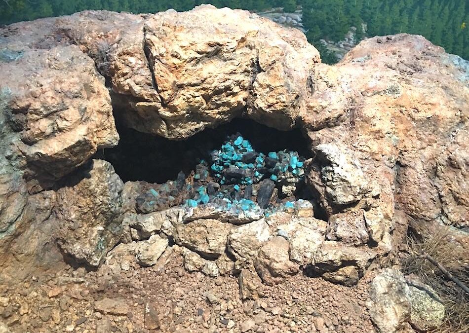
By mid-June, new exploration efforts were finally underway and a new pit, Pit D, was explored. As luck would have it, the first day of digging revealed an extraordinary pocket. On the surface, a few small fragments of deep blue-green amazonite (called “color” by local diggers) were lying exposed on the dump of a small hole dug years earlier. The hole was deepened and a nice pegmatite dike was exposed, the source of the color. The pegmatite plunged into the hill at a dip of 25 degrees to a depth of 2 meters below surface. Then, the dip changed to a near-horizontal position and the pegmatite began to widen into a lens. The lens soon discharged thousands of quartz and blue green amazonite fragments. It was obvious that a large pocket was about to be breached and within 30 minutes, a pocket opening could be seen.
The Tree Root Pocket. The pocket lay only 2 meters below the surface next to a large tree. The broken root (left center) was followed directly into the pocket.
At first, the pocket contents did not look good. Several single amazonite crystals were pulled out, most were damaged. But then, a few groups of amazonite and quartz came out. The first groups were heavily damaged but within a couple of hours, two very nice groups were pulled out. By the end of the first day, four killer specimens had been collected.
Close-up of material initially taken from the Tree Root pocket.
The crystal groups exhibited great aesthetics but at this point one could not determine if the amazonite color was very good. Every piece was stained with limonite. The color could only be determined later at the laboratory where the specimens would be cleaned.
By the second day, it became apparent that the pocket was large. It was already over 1 meter deep.
The Tree Root Pocket. Note the hard graphic granite layers above and below the pocket opening. The pocket lies sandwiched between them and is mostly collapsed. Any remaining open space is filled with iron-stained clay. The graphic granite and pocket compose the pegmatite while the finer grained granite above and below (the graphic granite) comprise the granite host-rock.
The pocket was mostly collapsed, the roof having fallen in, perhaps, millions of years earlier. The opening uncovered the previous day was originally created when the graphic granite roof plates separated from their finer-grained granite host-rock. The slightly decomposed host-rock did not have the strength to hold up the pocket roof.
A close-up of the Tree Root Pocket, about 16 cm high. The pocket is compressed and broken up. The plates growing down from the pockets’ ceiling have separated from the roof and fallen onto the floor plates. Much damage was caused by this collapse. All of the space left over after the collapse has filled with clay. A hint of the amazonites’ quality can be seen through the clay.
Thus, the roof plates had fallen straight down onto the plates growing up from the floor. This made a sort of amazonite “sandwich” with a clay filling. Every possible open space inside the “sandwich” was filled with clay, making specimen extraction difficult. The roof collapse created damage to many of the specimens. If the pocket had not collapsed, several hundred more beautiful specimens would have been recovered.
The proximity to the surface, and the subsequent ground water drainage through the pocket, was a detriment to pocket quality. The constant water flow helped destabilize and break down many of the amazonite crystals. Also, a tree root grew downwards along the pegmatite and into the pocket; it was one of probably hundreds through the years that grew into the pocket and slowly broke it apart. The tree root wound completely through the pocket to its very end, wedging and forcing the plates in all directions. In the tight confines of the pocket, the roots created extensive damage to the amazonite groups; the quartz terminations received the worst.
Another view inside the Tree Root Pocket. Tree roots have grown everywhere and have contributed to the breakup of the pocket.
Each day, 4 or 5 superb specimens were removed from the pocket, now named the Tree Root Pocket. For each nice group, about 50 broken pieces were extracted. Within a week, the pocket had opened up to 2 meters wide and about 1.7 meters deep. The opening never reached‘ more than about 20 cm high. The pocket was shaped like a kidney bean and lay more or less horizontally.
Every day for about 8 days, there was a collecting contest to see if the great piece pulled out today was better than the one collected yesterday. For the Tree Root Pocket collectors, this was a one-in-a-million field collecting experience. The pocket was cleaned out by the end of June.
By the end of June, the Tree Root Pocket was finally empty. Bryan Lees poses to show its total size: over 2 meters long. The opening only reached 20 cm high. Photo by Dave Roter.
Back at the Lab
Between the tree root, the roof collapse and its proximity to the surface, much of the Tree Root Pocket was either destroyed, damaged or disassembled. Most of the crystal group dismemberment involved the separation of amazonite from quartz. In the field, every piece removed from the pocket was carefully grouped and marked according to pocket location. Back at the Collector’s Edge cleaning facility in Golden, Colorado, they were finally washed off and examined.
Back at the Collector’s Edge cleaning lab in Golden, Colorado, Bryan Lees reviews the contents of the Tree Root Pocket. Hundreds of pieces ranging in quality from excellent to rubble now have to be carefully sorted and cleaned. Photo by Bernie Kowalski.
The first step in cleaning the pocket contents is a simple wash. Here, Robert Lorda removes a heavy clay layer coating a beautiful group of amazonite and smoky quartz.
After a simple spray wash, the true color of the amazonite begins to unfold.
After six weeks of careful, mind-numbing effort, the pieces worthy of repair from the Tree Root Pocket were finally complete. Many beautiful groups were saved in this fashion and of the final specimen total, about half were repaired. Also, most pieces had only one repair.
After a quick wash, Robert Lorda and Bill Hawes (in photo) begin the long process of piecing the pocket back together. Many fine amazonite and smoky quartz groups were saved in this fashion. It took two months to find all of the fits.
Many outstanding repairs were discovered, including this one. The repairs helped recreate the outstanding beauty of this pocket.
Before repair work, photographs were taken of each group. Following cleaning and repair, each group was again photographed and then cataloged. A catalog number was permanently affixed to the back of each specimen along with a small label marked “repaired”. Inside the catalog, each piece contained notations as to its number of repairs, field discovery location and other pertinent documentation.
During the puzzle work, a few of the pieces were finally cleaned yielding the biggest surprise to date. The amazonite color was incredible! The color is best described as deep blue-green, one of the finest amazonite colors. The luster is also good, but not perfect. On a typical crystal, a slight etching covered a few of the faces while others showed a brilliant luster. Crystal cross-sections showed that the deep blue-green color penetrated to the core.
After some cleaning, the deep blue-green color of the amazonite begins to stand out.
Late in the summer, the difficult cleaning work begins to yield some outstanding specimens. Here, groups are compared to photographs of their original uncleaned condition.
Jack Buckner, owner of the Two Point Mine, holds a beautiful specimen just completed. This is the repair specimen shown three photos back.
The specimens are finally finished; a table reveals the treasures of the Tree Root Pocket.
There were no “white caps” inside the pocket. “White caps” are an unusual white albite coating on the terminations and/or sides of amazonite crystals. Also, there were no baveno or manebach twins present inside the pocket, with the exception of one broken manebach measuring 9 cm across.
The blue-green color varied slightly from the edge of the pocket to its center. In the center of the pocket, the specimens were slightly more blue than the ones at the edges. But, even when putting the pieces side by side, it was very difficult to tell the difference between one which formed near the pocket’s edge and one formed near its center. The quartz crystals were gemmy and sometimes flawless. The color graded from medium to deep root beer brown giving them the varietal name of “smoky quartz”.
They reached 17 cm in length but only averaged about 6 cm, their luster is near-glassy. Most of the terminations took a beating inside the pocket from natural events; the collecting procedure did not damage them. Unfortunately, only a handful of pieces were completely damage-free. Still, upon casual inspection of most specimens, the damage was usually minimal or unnoticeable. The quartz created a stunning association with the deep blue-green amazonites.
The pocket produced two other associations of note. Several of the amazonite plates contained snow-white albite balls that measured to 4 cm and two pieces contained 1.5 cm cassiterite crystals. The plates containing albite balls, amazonite and quartz created a beautiful array of color. The Tree Root Pocket made its debut at the Denver Gem and Mineral Show in September, 1997 to an excited audience.
Display of amazonite and smoky quartz specimens at the Denver Gem and Mineral Show, September 1997.
Further Work
After the Denver Show, an effort to excavate below the Tree Root Pocket was undertaken. A mine program was put together to drill and blast 30 feet below the pocket. Unfortunately, not a single additional pocket was discovered at depth, a surprise to everyone. Pit B was also revisited and it too was drilled and shot extensively. Again, no material was found. By the middle of October, blasting work was completed and the pits were reclaimed and re-seeded.
In October, Graham Sutton drills, blasts and deepens Pit B, yielding nothing. This area was filled and reclaimed.
Removing the blasted overburden.
Pit B after reclamation. Seed being sown over site.
Final reclamation with trees being planted.
Much additional geological information was collected from field observations made during the 1997 work. The Tree Root Pocket occurred at the intersection of its pegmatite host dike and a major north-south structure. This intersection-type was similar to the one located in 1996 inside Pit C. Also, in October, 1997, a small test pit dug on the north end of Pit A yielded another pocket inside one of these intersection-types. While there seems to be a correlation of pockets being discovered at the intersections of north south fault structures and pegmatites, not all intersections yield pockets.
Further work on the Two Point Mine evaluated other potential intersection sites. There were two sites left at the Two Point Mine to explore. These were looked at during the 1998 mining season but are not reviewed in this article.
The Tree Root Pocket contained possibly the highest number of fine amazonite and smoky quartz groups ever documented from the Lake George region from a single pocket. The Tree Root Pocket produced over 100 cataloged amazonite and smoky quartz groups. The pocket also produced 100’s of single amazonite crystals and small amazonite groups. The Tree Root Pocket’s overall quality, quantity and beauty have not been surpassed in over 100 years of digging in the region.
In the past, because most amazonite pockets are collapsed and the crystal groups disassembled, few amazonite and smoky quartz groups survived. Given the improvement in digging and repair techniques during the l990’s, the potential for future important large finds is very good. Careful pocket documentation and repair work will yield higher percentages of fine specimens than ever before. Market acceptability of finely-repaired specimens will give the field collector the incentive to save and repair important pieces.