Collector’s Edge Minerals, Inc. recognizes and thanks Rocks & Minerals for permission to use portions or all of their original article from the “Rocks & Minerals”, Volume 65, Number 3, pp. 202-222. Contributing authors were Peter J. Modreski, U.S. Geological Survey, Denver, Colorado; Bryan Lees Collector’s Edge, Golden, Colorado; and Dennis Wilson, Lakewood, Colorado. Collector’s Edge has made some additions and changes to the original article which are incorporated below.
Stoneham, Colorado, is not famous for spectacular mountain scenery or champagne powder skiing, but this small hamlet in northeastern Colorado is known throughout the mineral world for its occurrence of stunning blue barite crystals.
In July 1989 Bryan Lees (CEMI) and Dennis Wilson formed the Leeson Partnership and after negotiation with the Niklas Ranch Company, they entered into a contract to lease the mineral rights to an area on the ranch property near Stoneham. Immediately after signing the agreement, they began an excavation at this Dana locality to follow a fault zone that appeared to be a locus of barite mineralization. A trench, ultimately about 45 meters long by 9 or more meters wide by as much as 15 meters deep, was excavated in a hillside and subsequently filled and regraded. Two major pockets (3 by 2 by 1.5 meters, and 3.6 by 1.2 by 0.25 meters) and a number of minor ones were encountered, producing several thousand excellent barite crystals and crystal clusters, some with associated calcite. The barite at Stoneham occurs in a bed rich in montmorillonite clay, derived from alteration of volcanic ash, in the Chadron Formation of the White River Group of Oligocene sedimentary rocks. The barite crystals, as much as 10-15 cm long, crystallized from ground water within open pockets that formed by movement along a northeast-dipping reverse fault that cuts the clay bed.
Location
The collecting site is in the high plains of northeastern Colorado about 150 km from Denver. It is located 10.3 km north-northeast of the town of Stoneham in eastern Weld County and is easily accessible by paved and well-travelled highways to within about 5 km of the actual collecting site. Here, a graveled, all-weather, ranching road can be utilized to get within about 300 m of the general collecting area. The locality is conspicuously visible from many kilometers distant, and can be recognized by its odd prominence as a bright, white flat-topped hill rising above the rest of the surrounding prairie. The north flank of this promontory has been eroded into a small horseshoe-shaped basin that has locally been called “the Blowout”.
View uphill (southeast of the site prior to start of excavation. Dirt piles in foreground are debris from pits dug by hand between 1985 and 1989.
It is in the southwest corner of section 15, Township 8 north, Range 56 west, and is in the southeast portion of the Stoneham NW 7-1/2-minute topographic quadrangle, which in turn lies in the northwest corner of the Sterling 1o by 2o quadrangle. This region of Colorado consists of plains and badlands dissected by the South Platte River and its tributaries. The South Platte lies about 40 km south of Stoneham, passing through the towns of Fort Morgan and Brush, from which it flows northeast toward Sterling, about 32 km east of Stoneham. This dissected area rises northward to an elevated plateau along the Nebraska border known as the Chalk Bluffs and, slightly further eastward, the Peetz Table. The two Pawnee Buttes, prominent topographic, historical, and paleontological landmarks of the area, are located about 32 km northwest of Stoneham in the Pawnee National Grasslands.
Elevations in the region range from 1219-1341 meters along the South Plate River, 1371-1432 meters near the collecting are, to 1219–1615 meters on the Chalk Bluffs. Land in the area is under varied private and public ownership; the site described here is on private land of the Niklas Ranch and has been the principal focus of collector’s activities for the past few decades. However, barite crystals are also known to occur throughout a wide area of northeastern Colorado in Weld, Logan, Sedgwick, and probably other counties in Colorado and adjoining states, wherever rocks of the White River Group are exposed (Scott, 1978; Workman, 1964a, b; Mitchell, 1960). Many early descriptions cited “Sterling, Colorado” as the source of the crystals, much the way that amazonite and smoky quartz from Colorado were commonly attributed to “Pikes Peak”; but most of the better barite specimens from northeastern Colorado have come from the vicinity of Stoneham. Sterling (in Logan County) was simply a larger and better-known town.
History
One might speculate that barite crystals in the Sterling region may well have attracted the attention of Ute or Arapahoe Indians, although there is no historical or archeological record of their knowledge or use of the crystals. The geology and paleontology of the region was first explored in the 1870s by the Hayden Survey and by O.C. Marsh, E.D. Cope, and others (Galbreath, 1953). Even though it has often been stated that the occurrence of barite became known in the 1870s, we have been unable to locate any published reference to barite crystals in this part of Colorado at the time or even in the 1880s. In particular, the “Catalogue of Minerals Found in Colorado” by F.M. Endlich (1878), a part of the Tenth Annual Report of the Hayden Survey of the Territories, does not mention Sterling or any other place in northeastern Colorado among the localities for barite, , although it has been erroneously quoted as having done so by sever writers (for example, Eckel, 1961). The locality was not mentioned in the fifth edition of Dana’s System of Mineralogy and its three appendices (J.D. Dana and Brush, 1884), but it does appear in the sixth edition of Dana (E.S. Dana, 1892, p. 904) and in the “Catalogue of American Localities of Minerals” that was included in this volume (simply stating “In Colorado, at Sterling, Weld County” and “Near Sterling, blue barite!”). The locality is noted in the alphabetical list of “The Minerals of Colorado” published by J.S. Randall (1893) in the State School of Mines Scientific Quarterly, but it did not appear in earlier versions of Randall’s list (1887, for example) or in the “Catalogue of the Principal Minerals of Colorado” published in the biennial reports of the state geologist for 1879-80 and 1881-82 (Smith, 1880, 1883) or in “A List of Specially Noteworthy Minerals of Colorado” by Cross (1885). Randall (1893) stated (p. 124): “Weld County – Pale blue crystals from minute ones to those several inches in length are found in fragile calcite near Sterling. Nearly all the crystals are terminated and some of them doubly terminated.”
It is actually somewhat remarkable and puzzling that the barite in northeast Colorado seems to have escaped notice of the early geological surveys of this area and that the occurrence seems to have gradually come into common knowledge in the early 1890s apparently without ever having been described in detail in any geological report. In fact, no description of the barite amounting to more than a sentence or two appears to have been published at all until the one-page article by Ellermeier (1948) in Rocks and Minerals! A more diligent search of old USGS and Colorado geological reports may well turn up some hitherto unrecognized published account of the Weld County barite.
Two drawings of barite crystals from Colorado appear in Goldschmidt’s Atlas der Krystallformen (1913). One of these, a prismatic crystal from “Colorado”(table 167, figure 481), which was taken from Dana (1892, p. 901, figure 12), might resemble a typical crystal from Stoneham except that it is labeled as being elongated on the a axis, whereas all Stoneham barite is elongated on b (Workman, 1964a). The other Colorado barite figured in Goldschmidt, a complex crystal in table 180, figure 672, is from “Apishapa”, Colorado (= the Apishapa River region, Otero, Pueblo, and Las Animas counties).
Throughout the past century innumerable collectors and geologists have visited the Stoneham area, and many, usually short, articles have been written about their observations and exploits (Ellermeier, 1948; Cook, 1952; Anonymous, 1960; Workman, 1963, 1964b; Eklund, 1965; Bennett, 1986; Voynick, 1988). A master’s thesis by W.E. Workman (1964a) provides a wealth of information about the occurrence and crystallography of the barite and about its distribution throughout eastern Weld and western Logan counties.
Although some barite may occur as individual crystals embedded in the clay, or in small isolated pockets, the best barite crystals have been said to occur in calcite-filled veins (Pearl, 1972). Clarence G. Coil and O. Art Reese conducted a very successful dig for barite crystals at Stoneham in the summer of 1953, according to an unpublished manuscript by Coil and Reese (1977) in the files of the Department of Geology, Denver Museum of Natural History. Digging a pit from the surface, they followed a seam that dipped into the hillside at a 45o angle and opened into a large tunnel to dome-shaped cavity. Coil and Reese described this tunnel as extending as much as 13.8 meters underground from its entrance and evidently being large enough for them to walk “stooped over” in at least parts of it. They collected a large number of barite crystals, described as being up to 15-18 cm in length. One large specimen, an approximately 30-cm plate containing some 115 barite crystals embedded in calcite matrix, was acquired by Harvard University. This specimen (HMM #131073) was pictured and described in an article in the 11 December 1955 (Colorado Springs) Gazette Telegraph (p. B-1). Around this time collectors made several other excavations by hand and at least one with a bulldozer. The Denver Museum of Natural History has a 12.7 cm barite cluster (DMNH #12790) with one large doubly terminated crystal, collected by Ed Over around 1952. Other Stoneham specimens in the Denver Museum collection date back as far 1912 to 1918.
The Stoneham area has remained a popular mineral collecting site over the years, with some collectors making occasional forays to prospect for barite in other outlying areas. Except for some periods when permission to enter the private ranch lands was not available, individuals and mineral clubs have continued to visit the site north of Stoneham up to the present. In May 1985, Luke and Cathy Westervelt and Norman Bennett spent eight days digging at Stoneham and found a pocket of fine large crystals and crystal clusters associated with pale yellow calcite (Bennett, 1986). They described pockets up to 2-5 meters across, located by digging along a “seam or joint” that dipped downward 15o-45o into the clay. They noted that pockets were found where the seam was most nearly horizontal. One large plate (DMNH #16305) of calcite-encrusted barite from this find is now in the Denver Museum collection, having been purchased with funds donated by the Greater Denver Area Gem and Mineral Council. It measures 43 by 23 cm across and contains approximately seventy-five exposed crystals, the largest of which is about 14 by 3.8 cm.
Recent Activities
In the spring of 1989 yet another fine pocket of blue barite was discovered along the same seam or fault zone by Dennis Wilson and Jim Smerglia, both of Lakewood, Colorado. The pocket was hand excavated by both men and Rick Estes. They removed some 3.7 meters of overburden clay to reveal a pocket approximately 0.6 to 0.9 meters wide and about 1.2 meters long. It contained dozens of fine specimens of barite with calcite, three of which were very good pieces resembling the material that had been excavated in 1985.
With the recent successful discovery, Dennis Wilson and Bryan Lees, CEMI, decided to explore for still deeper potential barite pockets. Digging by hand was getting to be out of the question because the clay overburden was now dangerously high and extremely difficult to remove, so other means were considered. Wilson and Lees formed the Leeson Partnership in July 1989. After some negotiation with the Niklas Ranch Company, they entered into a contract to lease the mineral rights to an area on the ranch property and set up a schedule for excavations. It was decided to bring in a 955 Caterpillar crawler-loader. Al Herman, of Western Construction in Greeley, Colorado, was contacted to handle the earth-moving operation. It was hoped that this equipment would be large enough to remove the deeper and more compacted clays. Donna Niklas and her son Wray were both interested in learning more about the geology of their property and the surrounding area; it was hoped that an excavation of the contemplated magnitude would provide some new geological insights. Peter Modreski of the USGS, was invited to visit the excavations to help document the dig and record geological observations that might be of general scientific value. The ultimate result of the project was the discovery of the deepest pockets of barite crystals yet found at Stoneham, many containing pristine gemmy barite in superb clusters and individual crystals. Some of this barite was associated with a druse of unusually attractive snow-white calcite crystals, making some of the most beautiful specimens ever found at Stoneham. They obtained what are some new and useful insights into the geological factors that have controlled the deposition of barite at Stoneham.
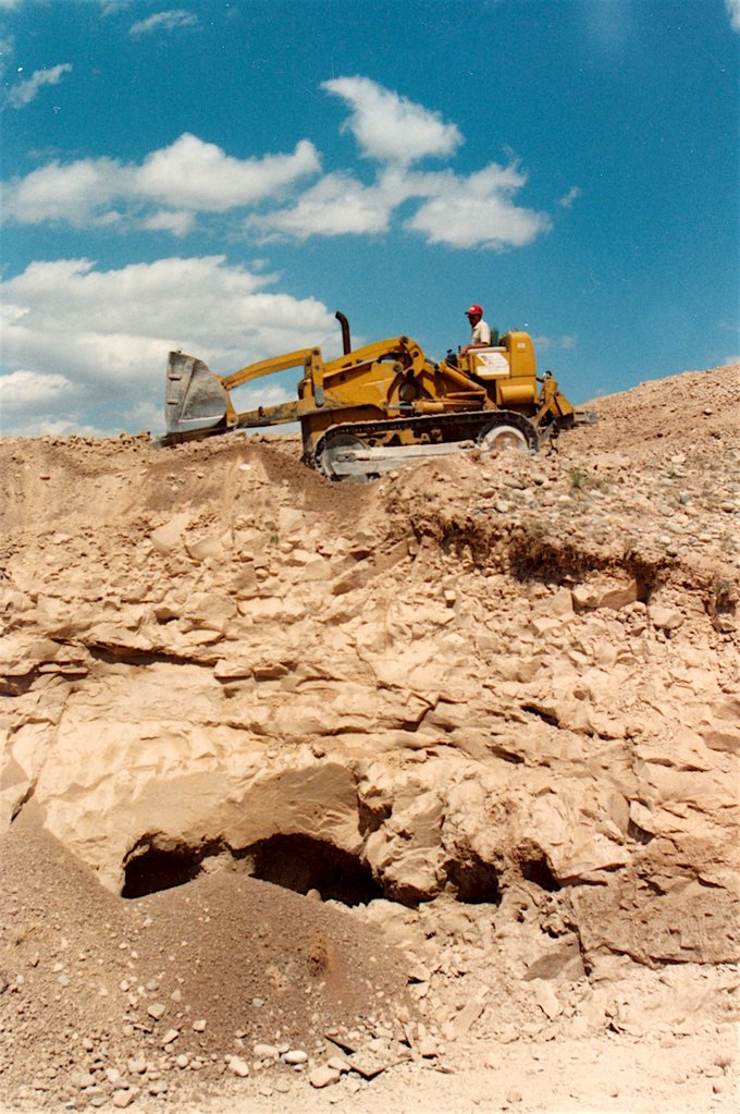
Northeast wall of the trench at an early stage in the excavation. Pits visible below tractor are the bottoms of tunnels hand dug by previous collectors.
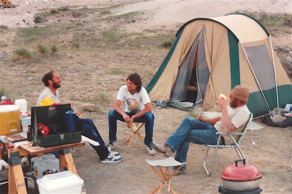
The dig began on 14 July 1989. The first day of the two-week excavation consisted of moving in the tractor, staking out the perimeter of the site, and setting up camp. The Colorado summer tornado season made this difficult, as ominous thunderstorms and twisters roared by through various quarters of the county; tents and tarps took a log of abuse. A sign was posted at the entrance to the site for the duration of the dig: “Collectors – a geologic study is being conducted under lease. Absolutely no one permitted in marked areas. We appreciate your cooperation. Good Hunting!”
Sign posted at entrance to site.
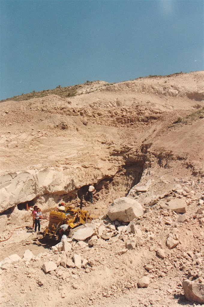
The next day the excavation began in earnest. First, the tailings piles from previous digs were cleared away, exposing several old hand-dug holes 0.6 to 0.9 meters in diameter leading down into the hillside. It took three days to finally get beneath the old tunnels. At that point the pit, trending N 55o W, was about 7.6 meters deep, 45.7 meters long, and 9.1 meters (at the bottom) to 30.5 meters (on the upper benches) wide. Lees and Wilson camped at the site continuously, one or both being present at all times. Modreski visited the site several times as the excavations progressed (on 15, 22, 23, and 24 July, though not often enough to see every major pocket) and after the dig and reclamation were completed.
Previous digging had focused on one major barite- and calcite-bearing seam or fault that appeared to dip into the hillside at about 30o. The digging strategy now was to undercut this zone and remove potential pockets from below rather than above; it was hoped this would reduce damage and allow the collection of larger intact “plates” of calcite-cemented barite crystals.
Taking a break from a long day excavating.
During the first three days of excavation a serious problem developed. The strength of the clay had been underestimated. Once the first few feet of relatively dry exposed clay had been removed, the fresh clay encountered was a rock-like heavily compacted material. It took a large ripper on the back of the tractor to break the clay enough to remove it. This slowed progress substantially; it took three times as long as anticipated to remove the clay.
Benches were cut into the hillside above to remove overburden and improve pit safety. It was hoped that other barite veins or pockets would be intersected during this process. None was found, however, so undercutting was continued along the original barite-bearing seam. At the end of the third day a fine barite pocket was uncovered along the main seam in the east end of the pit. It yielded some exquisite deep blue, gemmy barite crystal clusters several inches across. This pocket was about 45.7 cm wide, 5.1 – 10.2 cm tall, and 0.6 meters deep.
The next three days of overburden removal and pit deepening revealed sporadic small barite pockets along the exposed fault. The pit was now below the level of the old workings, and a 45.7 meter length of the barite-bearing seam was exposed. It was evident that this seam was in fact a fault within places- grooved and striated surfaces plunging down the dip of the fault surface. The dip of the fault was variable along its exposed strike length. The more steeply dipping (40o-50o) portions of the fault, often showing striated slickensides, seldom contained barite crystals or pockets and were often completely free of barite. The only calcite and barite showing in the cut were directly beneath the old workings, where the fault surface was more nearly horizontal. Calcite veinlets along the fault were exposed in a zone as much as 0.3 – 0.9 meters thick that extended intermittently for about 9.1-12.2 meters. The seam did not open into any pockets, however, and by the end of the dig’s sixth day the barite-calcite exposure disappeared completely from the seam. This was surprising because it had been anticipated that the calcite would thicken at depth.
Small pocket with deep blue barite crystals.
Bryan Lees holding a fine cluster of barite crystals from the small pocket behind him.
During the seventh day, undercutting continued along the seam. No barite or calcite was visible. Toward midday a brecciated clay zone 0.3 meters wide appeared along the seam. The tractor was stopped and the zone probed. Careful removal of the brecciated clay revealed a small opening into a dark cavity. A flashlight was inserted into the opening, revealing a breathtaking sight. “Barite wasteland!” was the first printable phrase uttered. This was followed by “How far does it go?” A 3 meter wide, 1.8 meter deep, 0.15 meter high barite-coated “forest” had been uncovered.
Excavation during the uncovering of pocket #1, showing fault zone extending the entire length of the trench and disappearing at the top of the white clay bed at the back of the cut.
Part of pocket #1, showing flat floor and roof, with a “forest” of barite crystals growing from the bottom.
A later stage in the excavation of pocket #1, showing flat roof along the fault surface, which bends to a steep dip at the upper right of photo.
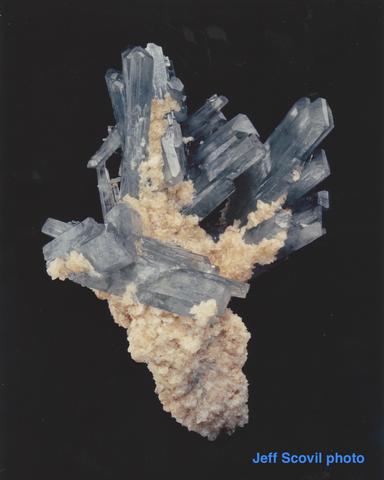
This was the first major pocket uncovered during the dig. When it was illuminated enough to see inside clearly, it was evident that the base of the pocket was very flat. It was later realized that this plane maintained a constant level and had the continuity of a bedding plane or a horizontal joint within the clay unit being excavated. The fault appeared to have intersected this horizontal plane and pushed it apart, thus forming an open space for barite deposition. The entire bottom of the pocket was covered with free-standing barite crystals, held together by smaller barite prisms or by a thin crust of calcite. An evident lack of fault movement following the barite deposition allowed the pocket to remain almost entirely intact. The lack of a calcite coating helped reveal very delicate, fine blue barite crystals forming a lattice-work that supported the larger barites and held them in place. The barite crystal clusters ranged from single blades to groups of a dozen large crystals. Toward the front of the pocket, the amount of calcite was minimal, usually forming small crusts preferentially coating the barite crystals along one side. Farther inside the pocket, the calcite became thicker, thus helping to form larger plates of up to two dozen barite crystals. The calcite was certainly the key to holding together the larger pieces. Once calcite-coated plate pulled from the center of this pocket weighed over 45 kilograms. The pocket contained hundreds of barite crystal groups.
Close-up view of a crystal plate of barites and calcite insitu.
Another close-up view of barite crystal clusters within the seam.
Following several hours of general gawking, stumbling around, and congratulations, it was realized that more equipment would be required to excavate the pocket properly. A 2.3 kg sledge and a gad-pry bar were not going to handle it. For two more days additional overburden was removed pending the arrival of air compressors and drills. During the waiting period the pocket was drying out, and had to be wetted every few hours to allay concerns over pocket deterioration. The ceiling was starting to dry out and small portions were caving down onto the specimens.
Working to remove specimens from the pocket.
Finally the compressor, drills, and more help arrived. George Robertson of Canon City, Colorado, handled the drilling phase of the operation, and beautiful specimens began to come out of the pocket. The entire pocket was undercut so that large barite groups could be removed without damage. This worked extremely well. As a section of the clay was cut back, one could reach into the pocket and wiggle the loose clusters until one came up and out. A contest ensued. At first, it was a competition to see who could pull out the specimen of the hour. After a short time, it became a question of who could pull out the specimen of the quarter-hour. Fine piece after fine piece came out of the pocket, each one outdoing the previous. It took two people wrapping and packing with one person in the pocket. This went on for three days. Chauncey Walden, of Littleton, Colorado, visited the site during this period and took stereo photographs of part of the pocket, which had unfortunately been largely emptied of crystals by this time.
Air supply hose from compressor to air tools in the excavation.
By the thirteenth day of the dig the pocket was empty, and the fault continued its dip into the hillside. Excavation proceeded without results, and the fault seemed to lose its identity at depth as the clay of the Chadron Formation gave way to what is believed to have been the underlying Pierre Shale. Near this contact the rock became more permeable, and water began seeping out of the exposed face. The first big pocket had been positioned about 6 feet above the supposed contact with the Pierre Shale and a total of about 11.7 meters below the original ground surface on the hillside above.
Wrapping specimens as soon as they are recovered.
The next day was scheduled for pit refilling and the beginning of land reclamation. There was only one area of the pit to be explored before finishing the work. No other exposure in the pit showed any sign of barite or calcite. This last area was in the eastern end of the pit, farthest into the hillside, where the fault had not yet been excavated down to the level of the Pierre Shale. The fault along this end of the pit had been producing sporadic small pockets of aquamarine-colored lustrous, gemmy barite crystals but not any good crystal groups. It was though that this area might provide the finest pieces of the dig if the fault would widen out to provide enough room for good barite deposition.
Excavation continued along the fault in the pit’s east end until it intersected what appeared to be the same horizontal layer as had contained the first big pocket. Again, a 25.4 cm zone of brecciated clay was uncovered and excavation halted. More careful breccia removal revealed a small dark void. Some small barite crystals could be seen disappearing into the darkness. When a miner’s light was inserted into this hole, there was a totally new surprise. Disappearing into a tube-like hole was a sold sheet of incredibly gemmy blue barite crystals, sprinkled with small white calcite crystals. Like the first pocket, this second one had a very little calcite matrix, although more calcite did appear when the back of the pocket was excavated. The first piece pulled from the hole had a matrix resembling a web-like network of inter-grown barite, something quite different from anything previously observed. This network held the specimen together and provided a base of support from which the larger barite crystals grew.
At this point everyone was totally exhausted, and the first comment was “Not another pocket!” This feeling ended quickly, however, as the first few pieces came out. Piece after piece emerged in perfect condition. If a section broke in two as it was being removed from the pocket, there were now two good specimens instead of one. Along sword (yes, a sword) was inserted into the opening underneath the sheet of barite and was rotated side to side until a plate was pried loose. The plate would then be lifted up and pulled out of the opening. The pieces excavated were clean, aesthetically attractive, and numerous. After about three hours of pulling specimens out of the pocket, everyone was literally giddy; even people with twenty-five years of collecting experience could not believe what they were seeing.
This second pocket measured about 3.6 meters deep, 0.9-1.2 meters wide, and 0.15-0.23 meters high. It was tube shaped and occurred at the same intersection of the fault with a horizontal bedding plane. It took two days and nights to empty the pocket, which produced about fifteen hundred specimens.
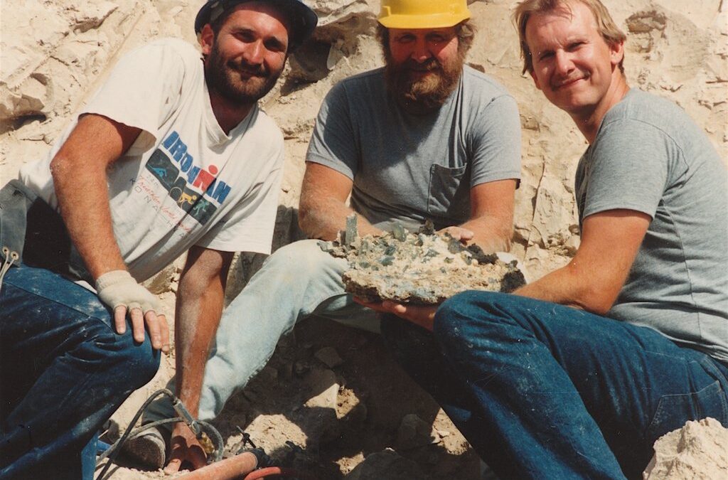
Collectors with a plate of barite and calcite (left to right): Dennis Wilson, George Robinson, Bryan Lees.
Pocket #2 after its complete excavation showing flat ceiling, brecciated zone at rear of pocket, and steeply dipping portion of fault zone above pocket at top right.
After the second pocket was mined out, continuing to follow the fault zone into the hillside would have necessitated further pit development to remove the overburden. This would have required extending the pit another 15-30 meters to the east. The fault within the pit had been excavated down to the contact with the Pierre Shale and showed no further signs of barite mineralization, in agreement with the general observation for the area that barite crystals are present only in the White River clays and not in the Pierre Shale. During the next three days, 27-29 July, the pit was filled back in. The area was contoured and the original drainage reconstructed to minimize future erosion.
View of the site before excavation.
View of the site after filling and grading of trench.
Field collecting, requiring the efforts of seven people, was only part of the project. After the dig an effort to clean the crystals began. This required five people full time for six weeks in order to have everything ready for the upcoming Denver mineral show. The final specimen count was about 3,000, of which 2,100 consisted primarily of single crystals and small groups. The balance of the specimens, about 890 crystal clusters, were carefully cleaned and numbered. Each piece was identified by the letter “L” followed by a number. This “L” signifies a specimen from the Leeson pockets. One 11.4 x 10 x 6.4 cm crystal cluster from pocket #1 of the 1989 dig is now on exhibit in the collection of the Denver Museum of Natural History (DMNH #16349).
Geology
Barite crystals near Stoneham occur in a near-white clay bed at the base of the Chadron Formation of the White River Group of sedimentary rocks, of middle Tertiary (Oligocene) age.
Stratigraphic column, Sterling-Stoneham area, Colorado; adapted from Scott (1978)
The White River Group covers a wide area in northeastern Colorado, southeastern Wyoming, western Nebraska, and western South Dakota. The geology of the White River Group in this region of the western Great Plains has been described by Galbreath (1953), Denson and Bergendahl (1961), Clark (1975), Denson and Chisholm (1971), Scott (1978), and Singler and Picard (1979, 1980). The White River sediments were transported and deposited by rivers generally flowing from west to east, following the end of the Laramide orogeny that formed the Rocky Mountains. Rocks of the White River Group are dominantly siltstone and claystone, with occasional beds of sandstone, conglomerate, limestone, and tuff (volcanic ash). The claystone beds in the White River Group have been formed by ground-water alteration of volcanic ash to montmorillonite clay. The volcanic ash may be fresh and unaltered, and recognizable as glass shards under a petrographic microscope, or it may be largely altered to montmorillonite.
The White River Group, formerly regarded as a single formation, is now divided into the Chadron and Brule formations (Bjorklund and Brown, 1957; Scott, 1978). The lower unit is the Chadron Formation of early Oligocene age (approximately 37-35 million years old), and the upper unit is the Brule Formation of middle to late Oligocene age (about 34-30 million years old). The Chadron was earlier referred to as the “Horsetail Creek beds” (=”Titanotherium beds”) of the White River Formation, and the Brule was divided into the “Cedar Creek member” (= “Oreodon beds”) and “Vista member” (= “Leptauchenia beds”) (Galbreath, 1953; Osborn, 1918). Rocks of the White River Group are noted for an abundance of fossil mammal remains, including such animals as the bizarre horned-nosed Brontotherium (titanothere); the rhinoceroslike Trigonias and Hyracodon; the three-toed ancestral horse Mesohippus; the ancestral camel Poebrotherium; the deerlike Oreodon; and the grotesque peccarylike ungulate Archeotherium (Matthew, 1901; Osborn, 1918; Galbreath, 1953; Kihm and Middleton, 1980). Strata and fossils of this age are found throughout the Colorado-Wyoming-Nebraska-South Dakota region and are especially well known from the Badlands National Park of South Dakota.
Younger rocks and sediment of the region have been eroded from the area near Stoneham. These overlying units include the lower Miocene Arikaree Formation, the Miocene Ogallala Formation that caps the Chalk Bluffs, and a number of alluvial and eolian deposits of Pleistocene and Holocene age (Scott, 1978). The Tertiary sedimentary rocks of the region are generally flat lying, except where they were tilted locally by Miocene faulting in parts of southeastern Wyoming, South Dakota, and northwestern Nebraska (Clark, 1975).
In the immediate area of the present study, white to tan clay-stones and siltstones of the White River Group form bluffs on a north-facing escarpment. Un-conformably below these Oligocene rocks, in badlands dissected by the tributaries of Pawnee Creek, are yellow-brown soft marine shale and clay-stone of the Pierre Shale of Late Cretaceous age. These oldest exposed rocks in the area were mapped as the upper transition member of the Pierre Shale by Scott (1978). Locally, farther west of Stoneham, beds of the marine Fox Hills Sandstone (Upper Cretaceous) lie atop the Pierre Shale. Scott (1978) on his 1:250,000-scale map of the Sterling quadrangle, did not attempt to distinguish between the Chadron and Brule formations of the White River Group. The Chadron Formation in the Sterling quadrangle is 30- 76 meters thick, and the Brule Formation is 61-152 meters thick. At the collecting site, a section of approximately 27 meters of Oligocene beds is exposed above the Pierre Shale; we assume that this basal portion of the White River Group belongs entirely to the Chadron Formation, although without fossil evidence or more extensive geologic mapping it is difficult to be certain.
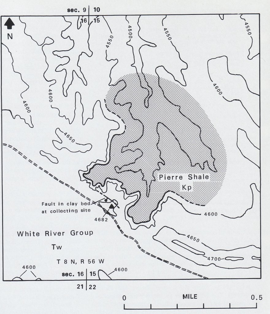
Preliminary geologic and topographic map of the collecting site in part of sections 15 and 16, Township 8 north, Range 56 west. Elevation contours in feet. Ball and bar symbol = fault observed at collecting site.
The volcanic ash that forms such a prominent component of the Oligocene rocks of northeast Colorado is likely to have come from the Thirty-nine Mile volcanic field of central Colorado, erupted between 36 and 29 million years ago as rhyolite and andesite from vents and calderas located between South Park and the present Sawatch Range (Epis et al., 1980). Some ash might also have come from the Yellowstone-Absaroka volcanic fields in northwest Wyoming (Singler and Picard, 1979).
The collecting site is on a hillside with a basal clay containing the barite crystals, overlain by a sequence of three white, relatively erosion-resistant, tuffaceous (volcanic ash-rich) beds, separated by three slightly softer, tan or gray siltstone beds. The seven harder and softer beds exposed in the hillside at the Niklas Ranch locality have been designated beds A through G. A topographic benchmark (1427 meters) is at the top of the hill, anchored in the uppermost tuff bed. Barite crystals occur in the lowest exposed bed (bed A), which is a massive, nearly white layer about 4.6-6.1 meters thick, lying atop the yellow-or olive-brown Pierre Shale. Petrographic examination and X-ray diffraction (XRD) show that the whiter, more resistant beds are rich in volcanic glass shards, in addition to containing fine-grained quartz, feldspar (sanidine and sodic plagioclase), illite, calcite, and montmorillonite clay derived by alteration of the glass. The softer, tan siltstone beds contain more detrital quartz plus a subordinate amount of feldspar, montmorillonite, and illite. The barite-bearing bed A is exceptionally rich in montmorillonite; glass shards in this bed are nearly completely altered to clay, whereas the three overlying ash beds (C, E, G) contain large amounts of fresh, unaltered glass and little montmorillonite. The underlying Pierre Shale can be distinguished from the Oligocene rocks by its yellow-brown or greenish-brown color, more abundant and coarser-grained detrital quartz, the absence of volcanic glass, less montmorillonite, and the presence of a small amount of kaolinite clay in addition to illite and montmorillonite. It is possible that the Pierre Shale, acting as a relatively impermeable barrier to water flow below the White River sequence, helped to keep the immediately overlying tuff bed (bed A) saturated with water, leading to the more extensive clay alteration in this than in any of the overlying tuffs.
Stratigraphic section in the hillside at the collecting site, showing the trench and the fault zone.
Volcanic glass shard in Chadron Formation (from tuff bed G, at top of hill); grain in center of photograph (0.8 by 1.1 mm) is glass with elongate tubular vesicles typical of rhyolite pumice. Photomicrograph in immersion oil, 400x.
The area immediately west and north of the barite locality is a shallow basin or “blowout”, eroded by wind and by arroyos that drain northward into Pawnee Creek. It is underlain by the Pierre Shale and rimmed by bluffs of the Chadron Formation with the white barite-bearing clay bed showing prominently at its base.
View northwest from the hilltop. The “blowout” is underlain by Pierre Shale and rimmed by white to tan cliffs of the barite-bearing Chadron Formation.
A slightly higher (1432 meters) continuation of the ridge to the east shows the barite-bearing white clay bed near its base, with an overlying sequence of siltstone and sandstone culminating near the top in reddish sandy beds that probably belong to the Brule Formation. About two-thirds of the way up this section is a calcite-cemented sandstone bed in which calcite “sand crystals” occur, as noted earlier by Campbell and Mitchell (1961). Most are inter-grown and less than 1 inch in size, but some form crude, rounded scalenohedral crystals up to about 5 inches long. About 1.6 km west of the barite locality are wells of the small Stoneham South oil field, which produces oil from the sub-surface Dakota Sandstone.
Residual cobbles and pebbles of quartz, pegmatite, quartzite, and other igneous and metamorphic rocks from ancient stream gravels are found atop the hillside at the collecting site. These represent deposits from stream channels that were ancestral precursors to the present South Platte River system. Scott (1982) mapped the gravel on this ridge as one of a number of channel deposits from an east-to southeast-flowing river system, possibly within the Brule Formation (apparently now completely eroded off this ridge, except for the residual gravel). Scott (1978) noted the occurrence of blue barite crystals and calcite “sand crystals” in the lower part of the Brule Formation, but he agrees that the occurrence of barite is not necessarily distinctive of the Brule as opposed to the Chadron Formation and at any given area barite might be expected in either unit.
Blue color is almost universally characteristic of Stoneham barite. In general, all freshly excavated crystals are blue, varying somewhat from dull gray-blue to vivid aquamarine-blue and greenish blue. Variations in clarity are probably more notable than differences in color; the crystals range from gem-clear to cloudy. Some show a slight zoning, either in degree of clarity or in depth of color. The blue color fades after prolonged exposure to sunlight; crystal fragments found lying on the surface are usually bleached colorless. However some collectors have also reported that the blue color of Stoneham barite intensifies after being excavated and exposed to sunlight, as is know to occur for barite from Hartsel, Park County (Belsher and Baldwin, 1980). A controlled study of the effect of light on the color of Stoneham barite would be worth pursuing.
Blue barite from many localities is known to be bleached by heating and restored or intensified by exposure to radiation (Hofmeister, 1984); however, the causes of color in barite are not well understood. Bershov et al. (1969) suggested that the bluish color in barite is due to radiation-produced color centers consisting of the trapped free-radical ions SO2– and SO2+. Bernstein (1979) studied these and other oxygen-sulfur ions that may contribute to color in the related iso-structural mineral celestite. Based on spectroscopic, heating, irradiation, and analytical studies, Hofmeister (1984) proposed that trace amounts of lead as Pb+3 ions, in combination with other as yet undetermined impurities, are the cause of the blue color in Stoneham (“Sterling”) barite. Hofmeister reported microprobe analyses of Sterling Barite showing 1.03-1.20 weight percent SrO and 0.11-0.23 weight percent PbO; her hypothesis of lead as the cause of blue color in barite is analogous to its verified role in producing the blue color of amazonite (Hofmeister and Rossman, 1985). However, other analyses (see below) have not confirmed the presence of this amount of lead in the barite. More recently, Paul Hlava (of Sandia National Laboratories, Albuquerque, New Mexico; as reported by Smith, 1989) has observed a correlation between the intensity of blue color in celestite with the abundance of the rare-earth element ytterbium. Future work may bring a more definitive answer to the origin of barite’s blue color.
Stoneham barite generally shows no fluorescence under ultraviolet (UV) radiation. A bright green fluorescence observed on the tips or faces of some crystals is due to a coating of uraniferous opal.
Barite can form a complete solid solution series with the isostructural mineral celestite, SrSO4, though most natural barites lie quite close to pure barite in composition (Hanor, 1968), as does the Stoneham barite. Barite crystals from Stoneham, and associated calcite, were chemically analyzed by Modreski using a KEVEX* energy-dispersive x-ray fluorescence (EDX-XRF) spectrometer, calibrated by a reference curve for mixtures with known strontium contents. Analysis of sixteen crystals from Stoneham showed a range of 0.15 – 0.60 weight percent SrO (equivalent to 0.3-1.4 mole percent celestite). Workman (1964a) reported eight emission spectrographic analyses of barite from different localities in Weld and Logan counties, ranging from 0.18 to 1.18 weight percent SrO. In addition, he gave four analyses of sheaf-like barite clusters from a locality between Stoneham and New Raymer that ranged from 0.47-1.42 weight percent SrO. The analyses of barite from the Stoneham locality appear to represent the low end of the range reported by Workman, whereas Hofmeister’s (1984) two analyses of 1.03 and 1.20 weight percent SrO lie toward the higher end of the range. Recent analyses also show an increase in strontium content during crystal growth, averaging 0.20 weight percent SrO in the interiors of all crystals examined, versus 0.32 percent in the outer zones of the prisms and 0.43 percent at the terminations. No other heavy metals were detected in the recent analyses of the barite, for which the limit of detection for metals such as lead should be about 0.01 weight percent. Workman (1964a) reported a trace of lead (0.025 weight percent) in only one out of twelve barite samples analyzed. His analyses also showed trace amounts (in decreasing order) of Si, Ca, Al, Mg, Fe, Cr (< 0.001-0.01 percent), Cu (<0.0005-0.002 percent), and Ti; the first several of these elements could be present as inclusions of clay or calcite in the barite.
Barite at Stoneham and elsewhere in the Weld County-Logan County area has also been described as sheaf-like crystal clusters (Workman, 1963, 1964a, b); “roses” or pale blue, opaque rosettes (Cook, 1952; Ellermeier, 1948); earthy concretions; and small crystal-lined geodes (Mitchell, 1960; Workman, 1964a).
The major occurrences of barite-lined pockets in the area studied have been localized along one major fault zone. From measurements in the 1989 excavations, this fault strikes approximately N 50o W and dips an average of 25o to the northeast. Locally, the dip on this fault varied from 0o to 50o. The fault was exposed along the length of the excavation in its northeast wall. The appearance of the fault varied from a sharp plane with no open space and little or no mineral filling, to brecciated zones several inches to 0.3 meters wide filled with clay cut by barite and calcite veins and minor open space, to large open, horizontal pockets as much as 0.3 meters high and 3.7 meters across. Grooved and striated slickenside surfaces were prominent on some steeply dipping portions of the fault zone. All measured striations plunged exactly down-dip on the fault, indicating that the only documented movement on the fault was strictly vertical (dip-slip). Open space along horizontal segments of a variably dipping fault would be produced by reverse-sense (hanging wall upward) movement; accordingly, we infer that movement on this fault was predominantly reverse.

Cross section showing location of 1989 and earlier pockets with respect to the fault zone and original ground surface.
Development of an open pocket by reverse movement along a variably dipping fault.
A traverse with a scintillometer across the fault as it was exposed in the wall of the trench showed just slightly higher radioactivity associated with the fault zone; 20-26 counts per second (cps) in the fault zone, versus a background of 16-22 cps in the clay bed away from the fault. The presence of uranium associated with the barite is evidenced by small amounts of green-fluorescent uraniferous opal deposited on some of the barite and calcite. The fault zone appeared to lose its identity and could not be traced into the softer siltstone bed above the massive clay, nor could it be traced into the underlying Pierre Shale.
The intact condition of the barite pockets suggests mineralization occurred after faulting. The largest and best pockets encountered in the 1989 dig occurred on horizontal or near-horizontal sections of the fault. Two extremely large horizontal pockets were encountered near the lowest level of the excavations, about 0.9-12.2 meters below the pre-excavation ground surface and a few feet above the contact with the underlying Pierre Shale. The clay at this level appeared to be harder and more competent, with a distinct horizontal break along a bedding plane or horizontal joint. Intersection of the fault with this horizontal zone of weakness may have caused the fault to take a more horizontal attitude. Reverse dip-slip movement along the fault then tended to pull the bedding plane apart and produce the space needed for pockets to develop. This separation varied in width from 15-30 cm, and the margins or contacts of the separated area were filled with a breccia of clay fragments. If the vertical distance of separation represents the complete extent of reverse dip-slip movement along the fault whose average dip is 30o-25o, then the total amount of displacement along the fault would be approximately 35-71 cm. The tube-like nature of pockets such as pocket #2 and the large “tunnel” reported by Coil and Reese in 1953 may in part represent courses for movement of ground water that developed along the fault zone.
Schematic cross sections through pocket #1, formed at intersection of the fault and a horizontal joint or bedding plane. A-A’ = section across fault outside the pocket; B-B’ = section through breccia at margin of pocket; C-C’ = section through center of pocket.
A second important control for barite mineralization was observed when two faults intersected. A series of openings – potential sites for barite and calcite deposition – tended to form along the line representing the intersection of two faults. Several such intersecting faults, generally with steeper dips than the main fault, were observed during the course of the excavation. At least one fault intersection yielded sporadic pockets to 31 cm wide, 8-15 cm high, and as much as 1 meter deep. Barite, however, did not crystallize as well or as prolifically as in the large sub-horizontal pockets described above.
Barite mineralization away from the may fault tended to be rather sparse. Some barite was present along less prominent intersecting faults. Flattened barite plates or thin layers of barite crystal druses were seen along some of these faults or simply along vertical joint surfaces. Some barite occurred in small (2.5-5 cm) isolated pockets, which were sometimes aligned in near-vertical zones. Some of the pockets in these vertical zones were angular and resembled tension gashes and were often lined with a soft white crust of relatively pure montmorillonite. Also seen along these vertical zones were hollow cavities that appeared to be casts of euhedral rhomb-like or hexagonal crystals, possibly calcite. Spots of black manganese oxide were often noted in proximity to barite-containing areas along the major fault and some other faults, suggesting that these may be a good indicator of barite mineralization.
The barite and calcite at Stoneham appear to have been deposited by ground water moving through fractures and permeable zones in the siltstone, clay, and ash beds of the White River Group. The major pocket-bearing fault zone provided both a conduit for mineral-bearing water and also the open spaces in which crystals could form. Barium to form the barite was presumably leached during alteration of volcanic glass in the tuffaceous beds, though we cannot rule out a contribution from heated (hydrothermal) water from depth. Sulfate could have been derived by solution of preexisting gypsum in the sediments [none is now seen] (Workman, 1964a). Other features documented in the Oligocene sedimentary rocks in adjacent states that testify to the movement of mineral material by ground water include chalcedony pseudomorphs after gypsum (Honess, 1923) and barite (Fraas, 1901; Workman, 1964a) and chalcedony veins, sometimes with calcite, in shrinkage cracks within clay (Wanless, 1922, 1924; Lawler, 1923). A more exact understanding of the mechanisms for the deposition of the barite will probably require more elaborate geochemical or isotopic studies of the various altered and unaltered rock units. Likewise, the age of the barite and calcite mineralization is presently unknown, other than its being post-Oligocene and post-faulting.
BARITE: BaSO4
Barite crystals at Stoneham range in habit from elongate prismatic to tabular.
Tabular-prismatic barite crystals (approximately 5 cm long) in a small pocket along the fault.
The crystals are flattened on the c-axis, and according to Workman (1964a) are always elongated on b. All gradations are seen from flattened tabular/prismatic crystals with a length:width:thickness (b:a:c) ratio of about 2:1:1/4, to highly elongate prisms.
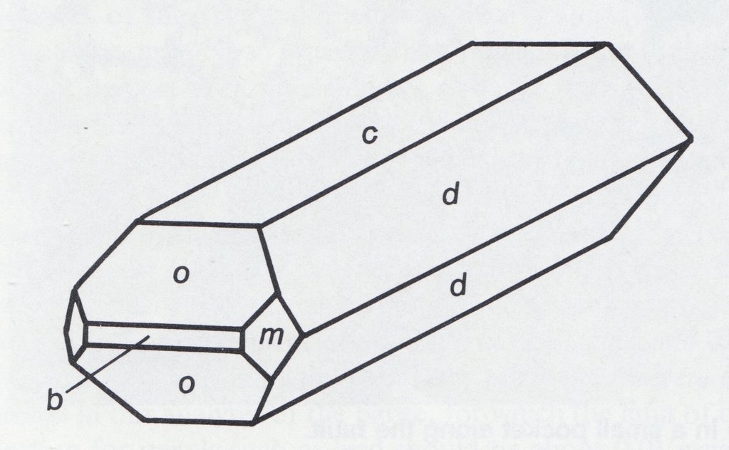
Crystal drawing of a typical barite crystal from Stoneham. Flattened prism elongated on b, showing c {001}, d {101}, o {011}, b {010}, and m {210}.
The bulk of the barite crystals found in the 1989 dig came from two major pockets (described as pocket #1 and pocket #2) that showed some significant differences. With several notable exceptions, barite crystals found in pocket #2 were generally similar to those that had been found in the 1985 and subsequent digs. One major difference was the lack of a thick layer of calcite within the seam. With less calcite, the barite crystals were more exposed so that the barite crystals on the plates appear less isolated. Typical small plates contained three or four crystals connected at the base by barite instead of calcite. The barite thus appeared to be “sprinkled with pale yellow to deep honey-colored calcite, making very attractive specimens. The calcite formed distorted rhombohedral crystals, 2-4 mm across. Some of the smaller, thinner overlying pockets exposed along the main fault in the 1989 excavation – or toward the rear of the large pockets – did, however, contain a larger amount of calcite completely surrounding or covering the barite crystals.
Barite crystals of pocket #1 commonly varied from 1.27 to 5.1 cm in length, with a few crystals up to 10 cm. Widths were usually 0.8 to 1.3 cm on the smaller crystals, to 1.9 – 3.2 cm on the larger ones, with a few as much as 7.6 cm across. Average thickness ranged from 0.4 to 1.2 cm. The typical crystal was about twice as long (b dimension) as wide (a). The color of the crystals ranged from medium to deep aquamarine blue, generally exhibiting a more delicate shade than many of the previously found crystals at Stoneham, which have inclined toward a grayish blue.
The large open cavity allowed the barite to grow without interference from the cavity walls or ceiling; the resulting lack of clay inclusions heightened the transparency of the barite. The smaller crystals were quite gemmy; the larger ones appeared slightly deeper blue but tended to be less transparent. Flaws along cleavage planes were often visible in larger crystals, possibly due to their having suffered minor thermal shock. If proper care was not taken, small flaw would often develop internally during the cleaning process as the barites were sprayed with water.
Pocket #2 was quite a surprise because it contained little or no calcite matrix. The only calcite present in this pocket was “sprinkled” on top of the barite crystals. This calcite was a distinctive white color, an attractive contrast to the blue barite. This “white calcite” later proved to be due to a thin coating of opal on the calcite. When first collected, a specimen could be turned upside down with a resulting show of small calcite crystals falling to the ground. Between 20% and 50% of the calcite coating fell off during cleaning.
A plate of barite with white (opal-encrusted) calcite as removed from pocket #2
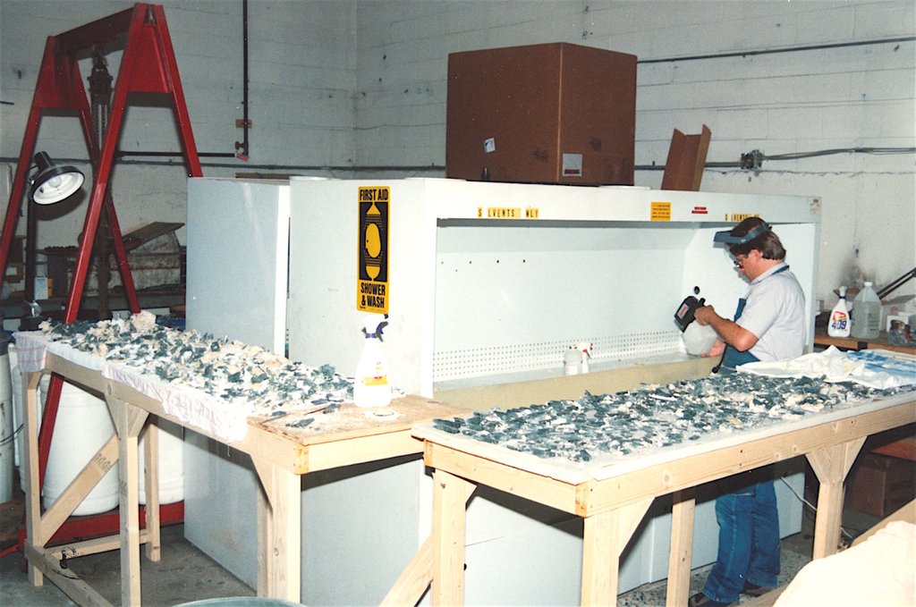
Barite being cleaned and prepped at Collector’s Edge laboratory.
Close-up of several specimens waiting for cleaning.
The structure of the barite plates in this pocket was totally different from that in pocket #1. The specimens consisted of dozens of very small barite crystals lying sub-horizontally and attached together in a criss-cross pattern forming a “basework” upon which the larger contrasting crystals had grown. A small plate of 5 – 7.6 cm might consist of a hundred crystals ranging in size from 0.6 – 1.3 cm long, on top of which would be the larger, 2.4-5.0 cm crystals. The small and delicate nature of material from this pocket created conditions ideal for the formation of hundreds of thumb-nail-sized specimens.
The barites of this zone were typically smaller than in pocket #1. They also tended to be more elongated on the b-axis with respect to their width than were the crystals in the first pocket. Pocket #2 contained very few really large crystals. The barite in pocket #2 was more gemmy and transparent and a deeper aquamarine-blue or greenish blue than in pocket #1. The color, clarity, and high luster of the crystals, plus the associated calcite and opal, resulted in these being some of the most aesthetically attractive specimens of the entire dig.